![ICON_Capture_edited.png](https://static.wixstatic.com/media/f97229_62fe3b34c83645f2a2240bc36ee64460~mv2.png/v1/fill/w_70,h_70,al_c,q_85,usm_0.66_1.00_0.01,enc_avif,quality_auto/ICON_Capture_edited.png)
CAPTURE
![ICON_Capture.png](https://static.wixstatic.com/media/f97229_bcc4151fade34191ad17b53c9dcfe6c4~mv2.png/v1/fill/w_70,h_70,al_c,q_85,usm_0.66_1.00_0.01,enc_avif,quality_auto/ICON_Capture.png)
CAPTURE
![ICON_Digitize_edited.png](https://static.wixstatic.com/media/f97229_20a67827a41a43239a3546d9f5a3c91c~mv2.png/v1/fill/w_70,h_70,al_c,q_85,usm_0.66_1.00_0.01,enc_avif,quality_auto/ICON_Digitize_edited.png)
DIGITIZE
![ICON_Digitize.png](https://static.wixstatic.com/media/f97229_a34c0a2071dd4fc3a1a4344340d704e3~mv2.png/v1/fill/w_70,h_70,al_c,q_85,usm_0.66_1.00_0.01,enc_avif,quality_auto/ICON_Digitize.png)
DIGITIZE
![ICON_Analyze_edited.png](https://static.wixstatic.com/media/f97229_f59d3e7c3ac54c3385706ba42ed133c7~mv2.png/v1/fill/w_70,h_70,al_c,q_85,usm_0.66_1.00_0.01,enc_avif,quality_auto/ICON_Analyze_edited.png)
CONTROL
![ICON_Analyze.png](https://static.wixstatic.com/media/f97229_8ea2231a17104fe0a2dfb0f45c06b0e5~mv2.png/v1/fill/w_70,h_70,al_c,q_85,usm_0.66_1.00_0.01,enc_avif,quality_auto/ICON_Analyze.png)
CONTROL
![ICON_Measure___Inspect_edited.png](https://static.wixstatic.com/media/f97229_67fde209f6034010a9bdfaf9293debe3~mv2.png/v1/fill/w_70,h_70,al_c,q_85,usm_0.66_1.00_0.01,enc_avif,quality_auto/ICON_Measure___Inspect_edited.png)
MEASURE & INSPECT
![ICON_Measure___Inspect.png](https://static.wixstatic.com/media/f97229_6f342ce561ac4f0984c05f8e9f43841f~mv2.png/v1/fill/w_70,h_70,al_c,q_85,usm_0.66_1.00_0.01,enc_avif,quality_auto/ICON_Measure___Inspect.png)
MEASURE & INSPECT
![ICON_Collaborate_edited.png](https://static.wixstatic.com/media/f97229_bdfdd20b73a3454faba1b68cb3a9b63b~mv2.png/v1/fill/w_70,h_70,al_c,q_85,usm_0.66_1.00_0.01,enc_avif,quality_auto/ICON_Collaborate_edited.png)
COLLABORATE & SHARE
![ICON_Collaborate.png](https://static.wixstatic.com/media/f97229_4c4370f953eb48e585b3a16aa69f0726~mv2.png/v1/fill/w_70,h_70,al_c,q_85,usm_0.66_1.00_0.01,enc_avif,quality_auto/ICON_Collaborate.png)
COLLABORATE & SHARE
![BACKGROUND_homepage_3D_mesh_2.jpg](https://static.wixstatic.com/media/f97229_89fb4fd633f04322b1088981b5093255~mv2.jpg/v1/fill/w_980,h_551,al_c,q_85,usm_0.66_1.00_0.01,enc_avif,quality_auto/f97229_89fb4fd633f04322b1088981b5093255~mv2.jpg)
Photogrammetry solution to power applications across industries
Advanced data processing for precise results
![photogrammetric_surveying.png](https://static.wixstatic.com/media/f97229_17d74d81bc2c4199a77167b0c0efb3fc~mv2.png/v1/fill/w_111,h_111,al_c,q_85,usm_0.66_1.00_0.01,enc_avif,quality_auto/photogrammetric_surveying.png)
Survey-grade Results
Obtain results with sub-centimetre accuracy thanks to photogrammetric analysis. 1-2 pixel GSD in X, Y directions 1-3 pixels GSD in the Z direction
![ICON_Complete_Control.png](https://static.wixstatic.com/media/f97229_101be6bd94c044cb9a1314997ea89642~mv2.png/v1/fill/w_111,h_111,al_c,q_85,usm_0.66_1.00_0.01,enc_avif,quality_auto/ICON_Complete_Control.png)
Complete control over your project
Define an area of interest, select processing options, add ground control points or edit point clouds, DSMs, meshes, and orthomosaics.
![photogrammetry_workflow.png](https://static.wixstatic.com/media/f97229_78c47a5d35bd449b9daaa8894a80e2c5~mv2.png/v1/fill/w_109,h_109,al_c,q_85,usm_0.66_1.00_0.01,enc_avif,quality_auto/photogrammetry_workflow.png)
Your work-flow, your choice
Use default templates for automatic processing of your projects, or create your own with custom settings for full control over the data and quality.
![desktop_raycloud_RGB.png](https://static.wixstatic.com/media/f97229_4bf2f35343434d028ce681f238482528~mv2.png/v1/fill/w_491,h_276,al_c,q_85,usm_0.66_1.00_0.01,enc_avif,quality_auto/desktop_raycloud_RGB.png)
rayCloud
TM
The power of photogrammetry software
A unique environment connecting your original images to each point of the 3D reconstruction to visually verify and improve the accuracy of your project.
The end-to-end photogrammetry tool for every project
Accurate 3D maps and models, purely from images
![accuracy_of_photogrammetry_edited.png](https://static.wixstatic.com/media/f97229_9cceaeb0090c44bfac2d57b5536c8823~mv2.png/v1/fill/w_50,h_50,al_c,q_85,usm_0.66_1.00_0.01,enc_avif,quality_auto/accuracy_of_photogrammetry_edited.png)
CONTROL OVER THE PROJECT ACCURACY
![accuracy_of_photogrammetry.png](https://static.wixstatic.com/media/f97229_4d780922bb6c4eeca990ee3b460f01c0~mv2.png/v1/fill/w_50,h_50,al_c,q_85,usm_0.66_1.00_0.01,enc_avif,quality_auto/accuracy_of_photogrammetry.png)
CONTROL OVER THE PROJECT ACCURACY
![ICON_Measure_edited.png](https://static.wixstatic.com/media/f97229_21dbaef850434a7bbb2a6256710e3312~mv2.png/v1/fill/w_39,h_39,al_c,q_85,usm_0.66_1.00_0.01,enc_avif,quality_auto/ICON_Measure_edited.png)
EASILY MEASURE SURFACE, DISTANCE & VOLUME
![ICON_Measure.png](https://static.wixstatic.com/media/f97229_e8be4ce6b74148ac82ac365dfdbf488d~mv2.png/v1/fill/w_39,h_39,al_c,q_85,usm_0.66_1.00_0.01,enc_avif,quality_auto/ICON_Measure.png)
EASILY MEASURE SURFACE, DISTANCE & VOLUME
![ICON_Edit_perfect_3_results_edited.png](https://static.wixstatic.com/media/f97229_d02afdf91e2e4257be25c9b88bea2ba0~mv2.png/v1/fill/w_39,h_39,al_c,q_85,usm_0.66_1.00_0.01,enc_avif,quality_auto/ICON_Edit_perfect_3_results_edited.png)
FLATTEN & SMOOTHEN DIGITAL SURFACES
![ICON_Edit_perfect_3_results.png](https://static.wixstatic.com/media/f97229_ee18f7630da244918759de33c07ae9f1~mv2.png/v1/fill/w_39,h_39,al_c,q_85,usm_0.66_1.00_0.01,enc_avif,quality_auto/ICON_Edit_perfect_3_results.png)
FLATTEN & SMOOTHEN DIGITAL SURFACES
![ICON_automatic_point_cloud_classificatio](https://static.wixstatic.com/media/f97229_4f0e8e453c4c452dbfdbc76a13829e27~mv2.png/v1/fill/w_39,h_39,al_c,q_85,usm_0.66_1.00_0.01,enc_avif,quality_auto/ICON_automatic_point_cloud_classificatio.png)
AUTOMATIC POINT CLOUD CLASSIFICATION
![ICON_automatic_point_cloud_classificatio](https://static.wixstatic.com/media/f97229_79a6f83488e7468d9ff5141b82cd2374~mv2.png/v1/fill/w_39,h_39,al_c,q_85,usm_0.66_1.00_0.01,enc_avif,quality_auto/ICON_automatic_point_cloud_classificatio.png)
AUTOMATIC POINT CLOUD CLASSIFICATION
![PICT_GEO_Reports_edited.png](https://static.wixstatic.com/media/f97229_0e2d4ac39ad64a8597673dc40ac52abf~mv2.png/v1/fill/w_50,h_50,al_c,q_85,usm_0.66_1.00_0.01,enc_avif,quality_auto/PICT_GEO_Reports_edited.png)
DETAILED QUALITY REPORT
![PICT_GEO_Reports.png](https://static.wixstatic.com/media/f97229_c1cc89d898734776a5db98ff9f8dacce~mv2.png/v1/fill/w_50,h_50,al_c,q_85,usm_0.66_1.00_0.01,enc_avif,quality_auto/PICT_GEO_Reports.png)
DETAILED QUALITY REPORT
![BACKGROUND_homepage_3D_mesh_2.jpg](https://static.wixstatic.com/media/f97229_89fb4fd633f04322b1088981b5093255~mv2.jpg/v1/fill/w_964,h_542,al_c,q_85,usm_0.66_1.00_0.01,enc_avif,quality_auto/f97229_89fb4fd633f04322b1088981b5093255~mv2.jpg)
Photos first
Any camera. Any drone. Any imagery. As long as it's a .jpg or a .tif.
Generate high resolution outputs for any project and use case
Easily export your digital maps and models to industry-compatible formats for further analysis or reporting
![IMAGE_OUTPUTS_PIX4DMAPPER_colorPointclou](https://static.wixstatic.com/media/f97229_ab65e32f75244a3eb73f9c9c6953f061~mv2.jpg/v1/fill/w_314,h_177,al_c,q_80,usm_0.66_1.00_0.01,enc_avif,quality_auto/IMAGE_OUTPUTS_PIX4DMAPPER_colorPointclou.jpg)
Full-color point cloud
.las, .laz, .ply, .xyz
![IMAGE_OUTPUTS_PIX4DMAPPER_Orthomosaic.jp](https://static.wixstatic.com/media/f97229_8df2098a0ad445689f8bb5f55b7362fb~mv2.jpg/v1/fill/w_315,h_177,al_c,q_80,usm_0.66_1.00_0.01,enc_avif,quality_auto/IMAGE_OUTPUTS_PIX4DMAPPER_Orthomosaic_jp.jpg)
Orthomosaic
GeoTiff (.tif), .kml
![IMAGE_OUTPUTS_PIX4DMAPPER_DSM.jpg](https://static.wixstatic.com/media/f97229_3a34479a35f048eda3492e283cc0623d~mv2.jpg/v1/fill/w_317,h_178,al_c,q_80,usm_0.66_1.00_0.01,enc_avif,quality_auto/IMAGE_OUTPUTS_PIX4DMAPPER_DSM.jpg)
Digital surface model (DSM)
GeoTiff (.tif), .xyz, .las, .laz
![IMAGE_OUTPUTS_PIX4DMAPPER_3dTexturedMesh](https://static.wixstatic.com/media/f97229_038a1d9d2eda40f78c1198a6b462daf6~mv2.jpg/v1/fill/w_314,h_177,al_c,q_80,usm_0.66_1.00_0.01,enc_avif,quality_auto/IMAGE_OUTPUTS_PIX4DMAPPER_3dTexturedMesh.jpg)
3D textured mesh
.ply, .fbx, .dxf, .obj, .pdf
![IMAGE_OUTPUTS_PIX4DMAPPER_indexmaps.jpg](https://static.wixstatic.com/media/f97229_8c62ef7bbb314c9a9a82e610411b08e3~mv2.jpg/v1/fill/w_315,h_177,al_c,q_80,usm_0.66_1.00_0.01,enc_avif,quality_auto/IMAGE_OUTPUTS_PIX4DMAPPER_indexmaps.jpg)
Index map
GeoTiff (.tif), .shp
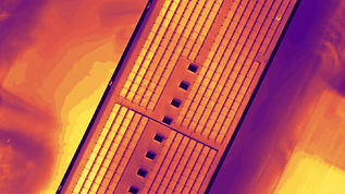
![IMAGE_OUTPUTS_PIX4DMAPPER_thermal.jpg](https://static.wixstatic.com/media/f97229_9eeaf49309b1483f9e98c41904d1ad12~mv2.jpg/v1/fill/w_317,h_178,al_c,q_80,usm_0.66_1.00_0.01,enc_avif,quality_auto/IMAGE_OUTPUTS_PIX4DMAPPER_thermal.jpg)
Thermal maps
GeoTiff (.tif)
Generate high resolution outputs for any project and use case
![HEA_BLO_GEO_why-ground-control-points-im](https://static.wixstatic.com/media/f97229_cb5737c7872543b8b9b70464ce73b0e5~mv2.jpg/v1/fill/w_284,h_160,al_c,q_80,usm_0.66_1.00_0.01,enc_avif,quality_auto/HEA_BLO_GEO_why-ground-control-points-im.jpg)
Ground control points: What are they and why are they important?
We discuss what are the ground control points (GCPs), how many are needed for an accurate aerial map, how they affect accuracy and why they look the way they do.
![Pix4Dmapper-raycloud-interface.jpg](https://static.wixstatic.com/media/f97229_c0ef693f419b4f78a49dd181936a7ed5~mv2.jpg/v1/fill/w_298,h_156,al_c,q_80,usm_0.66_1.00_0.01,enc_avif,quality_auto/Pix4Dmapper-raycloud-interface.jpg)
Faster processing and cleaner point cloud with Pix4Dmapper 4.5
We are happy to announce the latest and fastest version of Pix4Dmapper. Learn how you can process your projects faster and accelerate the point cloud cleaning.
![HEA_BLO_CORP_3dmodel-great-pyramid-pix4d](https://static.wixstatic.com/media/f97229_2710914bc90549c9914a04e14d8daada~mv2.jpg/v1/fill/w_284,h_160,al_c,q_80,usm_0.66_1.00_0.01,enc_avif,quality_auto/HEA_BLO_CORP_3dmodel-great-pyramid-pix4d.jpg)